Creating a Raspberry Pi ADS-B Receiver

Mark1966

Canberra dwelling Happy Clapping Bean Counter
Staff member
Site Moderator
Grand Society
2016 Sabbatical Fail
2018 Charity Auction Winner
2019 Charity Auction Winner
2020 Charity Auction Winner
Joined
Apr 26, 2011
Location
Canberra
As many of you would be aware, I've travelled enough for work (largely domestic) that I'm a bit of an 'avgeek'. I listen regularly to the FR24 AvTalk podcast and regularly use the FR24 website or app to track flights.

The FR24 Build your own ADS-B receiver instructions are OK, but link to overseas sites to purchase necessary items from, a little tedious. With a little help from Google though, I found these instructions from a local Australian supplier, which includes a video, for those that way inclined -


Even more usefully, they include a shopping list with links to all the necessary items on their site! So I purchased:
The case was not in their shopping list, but essential IMHO, and I already had a Micro-SD card reader which is necessary to be able to 'flash' it from my PC.

I'm thinking I will probably get an external antenna at some point - but that will be stage two of the project.

Everything arrived safe and sound very quickly after ordering -


I must give kudos to Core Electronics. I used their online chat feature to talk about what case to buy and how to set things up as I was originally thinking of installing the Pi in the roof cavity of the garage but that gets dusty and is hot in summer. They gave me some advice about that and the case to buy and then shipped VERY quickly - highly recommended.

Now to start playing!
 
Last edited:
OK, let's get into it!

[EDIT: There is an alternative, open source, image available at ADSB.im you can write onto you SD card which includes feeders for a wide range of sites. See more in this post below.]

The first step in the instructions refers to "the program Raspberry Pi Flasher", which is actually "Raspberry Pi Imager", but the links, detailed additional instructions and images are all correct - just a note for new players.

Being a curious newbie when I received this option -


I had to look at what the settings where to edit, and I noticed that you can enable SSH -


I remembered reading elsewhere that to add additional feeds this had to be enabled - so did so. This then required -


A username and password to be established. You can also add in WiFi details, but I am using ethernet.

As an aside, you can get a Raspberry Pi PoE+ HAT ( or maybe this one) and avoided the power supply to run the Raspberry Pi via PoE BUT wanted a solid, stable solution without that additional complexity until I unpacked the power supply and noticed -


Oh, I hate these power supplies with the 'wings' that extend so it does not fit into the space of a normal plug. A quick slice or two with the Stanley knife and these are GONE!

Put everything together, connected to monitor and powered up - it works!

It was about this point that I realised that I only needed the monitor cable to ascertain the IP address. For those with access to their router and network details you could do this through the router and avoid the $8.62 cost of the Micro-HDMI to Standard HDMI 1M Cable. I ended up setting a fixed IP address through my router for future convenience.

Next step, establish FlightAware account, easy, and then use the IP address in the browser to get to the status page of the Pi and use the "Claim this feeder to associate it with your FlightAware account" button to add it to my [Basic (free)] FlightAware account to feed to FlightAware and get an upgrade to their Enterprise account. You can see the additional benefits of an Enterprise account here.

This is where I encountered my only real problems. The browser just said "Loading" for ages. I waited, shut down the Pi, restarted, waited, all the usual stuff. I once got the not found message -

PiAware_Claim_webpage.jpg


Then just "loading" again ...

At this point I tried to get connected to Flightradar24, see below, and got that working. So I began to wonder if maybe it was a Firefox issue, and tried Edge, the only other browser on my new install, and hey presto - it worked. Firefox can sometimes be a problem :(

I am now the proud owner of a FlightAware Enterprise account and am feeding ADS-B data!
 
Last edited:
As I noted above, I could not get FlightAware to work for me initially, so tried to get connected to FlightRadar24.

The instructions here made it seem easy -

If you are already running a Raspberry Pi with DVB-T stick:
SSH into your Raspberry Pi and execute this command:
wget -qO- https://fr24.com/install.sh | sudo bash -s
You will be asked to enter your email address, antenna position and other details.

How hard could this be?

Well, how do you "SSH into your Raspberry Pi and execute this command"? There are details here:

https://www.raspberrypi.com/documentation/computers/remote-access.html#ssh

or Google is your friend -

Using PowerShell from a Windows PC
To SSH into your Raspberry Pi using PowerShell, follow these steps:
Open a terminal on the device you would like to SSH into your Raspberry Pi from. In these steps, we’re using PowerShell.
To open PowerShell, either press Ctrl + Shift + P, or hit the Windows key and manually search for PowerShell.
Enter the command: ssh [username]@[hostname].local or ssh [username]@[IP address], replacing [username] and [hostname] or [IP address] with the details of your Raspberry Pi.

So far so good, copied in the command above and pressed enter, hey presto things happen and then I'm told -

Welcome to the FR24 Decoder/Feeder sign up wizard!
Before you continue please make sure that:
1 - Your ADS-B receiver is connected to this computer or is accessible over network
2 - You know your antenna's latitude/longitude up to 4 decimal points and the altitude in feet
3 - You have a working email address that will be used to contact you
4 - fr24feed service is stopped. If not, please run: sudo systemctl stop fr24feed

1, 3 and 4 are easy - but what is my latitude/longitude up to 4 decimal points and the altitude in feet?

What is my latitude/longitude up to 4 decimal points - search your address in Google Maps and right click on the 'pin' - it gives you the latitude and longitude

What is my altitude in feet - enter your address here and you can ascertain this.

[EDIT: How to determine the latitude, longitude and elevation? This one site does it all: https://www.freemaptools.com/elevation-finder.htm.]


Entering all the data in response to the questions and it works, then I was given the message -

We have detected that you already have a dump1090 instance running. We can therefore automatically configure the FR24 feeder to use the existing receiver configuration, or you can manually configure all the parameters.
Would you like to use autoconfig (*yes*/no)$:​

This was a 'problem' I was warned about, trying to reinstall dump1090, so responded yes to autoconfig, and ...

Congratulations! You are now registered and ready to share ADS-B data with Flightradar24.
+ Your sharing key (***************) has been configured and emailed to you for backup purposes.
+ Your radar id is *********, please include it in all email communication with us.
+ Please make sure to start sharing data within one month from now as otherwise your ID/KEY will be deleted.
Thank you for supporting Flightradar24! We hope that you will enjoy our Premium services that will be available to you when you become an active feeder.

It all works! Too easy :)
 
Last edited:
So far the receiver has been up and running on the desk in my (upstairs) study in the house. After a couple of days running I looked at the stats -


This suggests to me that in that location it has a maximum range of 80 nautical miles or less. I've moved the receiver into its final (?) resting place within my server cabinet in the garage with the antenna on top. We shall see how that goes.


I'm kicking myself for getting a white power supply. I could not possibly plug that into the black power strip - so it is plugged into the spare power point at the back (OCD, me?)

Using the instructions here to work out the MAXIMUM possible range, it really is a huge area -


While theoretical, I'd certainly like to improve the range - so have ordered an antenna!

To give you an idea of the impact of my limited range. This is FR24 without any filtering -


This is a few seconds later filtered to just my receiver -


Notice how the flight closest to CBR airport drops off, it is at a lower altitude and presumably blocked by buildings etc from my receiver.
 
Last edited:
More to come here once the external antenna is received and installed, possibly in the roof cavity rather than outside ...
 
I don't fully understand?

WHY?

Do you really need this, unless you're worried a plane might fall from the sky and crash your home.
He has every DE razor ever made, the world's largest collection of fountain pens,, enough toy tanks to start a small war so why not devise a way of interrupting air traffic in Canberra
 
He has every DE razor ever made, the world's largest collection of fountain pens,, enough toy tanks to start a small war so why not devise a way of interrupting air traffic in Canberra

There may be a *little* hyperbole there ...

... and the model tanks have been sold.

Only really one fountain pen, but a couple of watches - not enough to be called a collection though.

Blocking flights in and out of CBR though - now that sounds like a hoot!!
 
There may be a *little* hyperbole there ...

... and the model tanks have been sold.

Only really one fountain pen, but a couple of watches - not enough to be called a collection though.

Blocking flights in and out of CBR though - now that sounds like a hoot!!
It could be a good way to wangle a day off when you really don't feel like heading off on another trip. :sneaky:
 
OK, some updates after a little more research - which I will also include in the earlier posts at some point to update them!

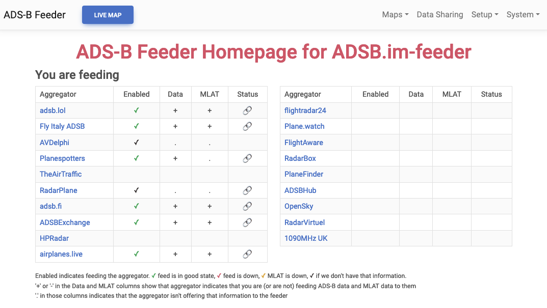
There is an alternative, open source, image available at ADSB.im you can write onto you SD card which includes feeders for a wide range of sites -

ADSB-im-v2.1.png


How to determine the latitude, longitude and elevation? This one site does it all: https://www.freemaptools.com/elevation-finder.htm.

Since moving my receiver out to the garage the range has increased - with some aircraft picked up in the 80-160 nm range:

 
Just to give you a sense of the range I'm currently getting -


Flights tend to drop off my receiver just after that aircraft north of Goulburn and once they hit Corryong
 
Antennae received (razor for scale) -


Let the fun commence!
 
Well some fun was had up in the roof cavity!

I have an old alarm system box where I replaced the old redundant NESS security system with a Konnected Alarm Panel Conversion Kit (highly recommended BTW) and diverted the ethernet cables from my NVR into a 6 port switch. That was the base for the ethernet cable to the Raspberry Pi which I zip tied to a roof joist -


Not pretty, but who cares! Who will see it :)

The antenna was screwed onto a bit of timber I had lying around, so glad that we keep these sort of things "just in case" and this was screwed onto an upright in the roof cavity -


Again, not pretty, but it works.

How well does it work?

Originally you will recall from the post above that the little antenna was getting to 80kms from my desk, and in the 80-160km range when installed in the garage. This new set up is getting some positions out to the 240 - 320km range -


Certainly flights from a larger area to the north of me are being picked up -


This screenshot I took not long after it was installed yesterday blew me away with the flights I was seeing, with a MEL - NAD flight having just dropped off range a little north east of Wollongong over the ocean -


The flights to the south of me coming into CBR airport are tracked much longer too.

Could I get more coverage with further tweaks? Maybe, but this will do me :)
 
BTW, if you want to see results from my receiver -

FR24, my 'radar' is T-YSCB230, you can filter for just results from that receiver.

FlightAware, my site is Site 235177
 
Just by way of comparison, flights tracked on my receiver -


Compared to flights tracked by all receivers -


Interesting (for me) to notice the differences, which are not merely distance but height and local topography etc
 
Last edited:
Top